Biodiversity Map Tracking using Open Biodiversity Datasets
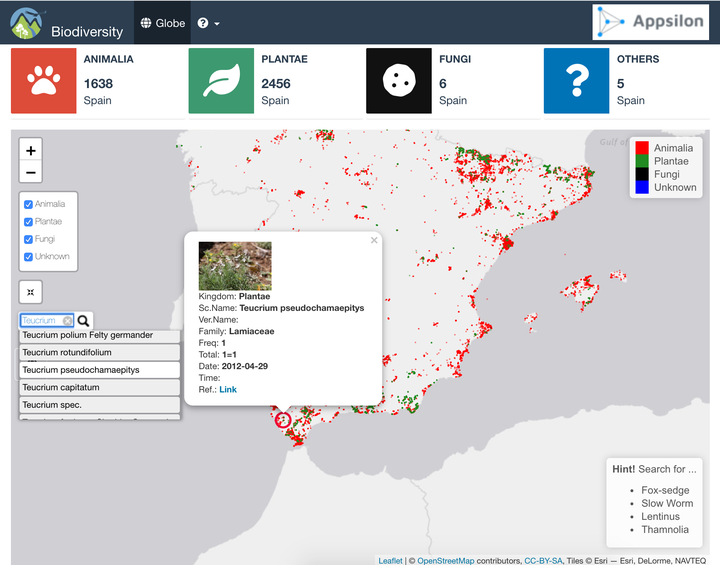
 screenshot
- biodiversity is a complete R package
- Build/Check/Test package
- Docker container is available.
- Extend search to multiple countries: Poland, Switzerland, Germany, France, Spain.
- Convert csv files to sqlite database.
- Faster read of tables
- focus search on selcted tables
- Add popup to select interested countries to focus on.
- Reduce waiting time and improve reactivity of the App.
- Limit functionalities to wanted countries
- Add Progressbar to inform the user what the app is doing
- Starting Map position focus of the mean(s) of latitude(s) and longitude(s) of selected Countri(es).
- User do not need to scroll the map to selected countries.
- Add a Layout control panel for existing Kingdom
- Rapid Overview of the position of Animals, Plants and Others
- User can focus search by Kingdom
- User can search by
vernacularName, the app returnsscientificNameand vice versa. - After searching and selected species from the search engine, the Map go and Focus on item position with:
- Indicate the position with red circle, and
- Open popup with all needed information:
- External link to original data,
- How many times the species has been encountered,
- Individual Count in each encounter,
- Image,
- Link to reference.
- Button to iterate search if user want to change/select other countries
- Info Boxes indicating the total of each existing king.
- CSS styling with logos in header, Absolute Panel with transparent Button